Climate Chart of Vail, USA
Comprehensive Climate Chart of Vail, USA: Monthly Averages and Weather Trends
Discover the climate of Vail, United States of America.
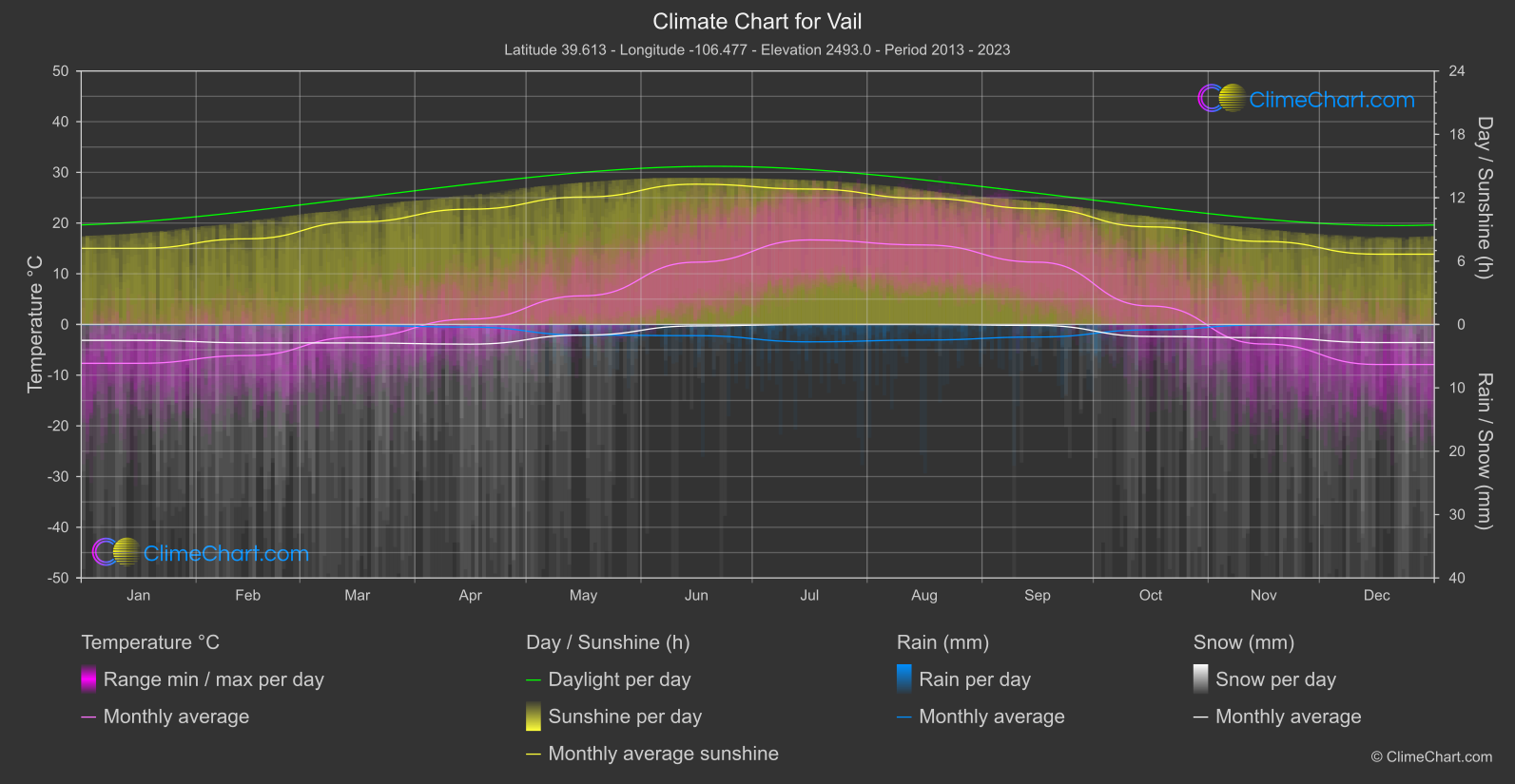
Vail, located in Colorado, experiences a semi-arid climate with cold winters and mild summers. The average annual precipitation is around 235 inches, with most of the snowfall occurring between November and April. The winter temperatures can drop below freezing, while summer temperatures range from mild to warm. Vail is known for its world-class skiing and outdoor activities, making it a popular destination year-round.
Best Travel Time Guide for Vail, USA: Ideal Seasons and Weather Insights
The best time to travel to Vail is during the winter months for skiing and snow activities, or in the summer for hiking and outdoor adventures. Avoid the shoulder seasons in spring and fall if you prefer more stable weather conditions.
Climate Data Overview for Vail, USA
Explore the comprehensive climate data for Vail, USA. This detailed table provides valuable insights into temperature variations, precipitation levels, and seasonal changes, helping you understand the unique weather patterns of this region.
| Month | ⌀ Temperature °C | ⌀ Rain (mm) | ⌀ Snow (mm) | ⌀ Sunshine (h) |
|---|---|---|---|---|
| Jan | -7.7 | 0.01 | 1.25 | 7.20 |
| Feb | -6.1 | 0.03 | 1.45 | 8.11 |
| Mar | -2.5 | 0.08 | 1.46 | 9.70 |
| Apr | 1.1 | 0.21 | 1.55 | 10.92 |
| May | 5.7 | 0.84 | 0.84 | 12.06 |
| Jun | 12.3 | 0.88 | 0.11 | 13.28 |
| Jul | 16.7 | 1.37 | 0.00 | 12.82 |
| Aug | 15.7 | 1.23 | 0.00 | 11.94 |
| Sep | 12.3 | 0.99 | 0.08 | 10.97 |
| Oct | 3.6 | 0.42 | 0.95 | 9.24 |
| Nov | -3.9 | 0.03 | 1.04 | 7.86 |
| Dec | -7.9 | 0.01 | 1.43 | 6.66 |
| ⌀ Month | 3.3 | 0.51 | 0.85 | 10.06 |