Climate Chart of Rottnest Island, Australia
Monthly data: Temperature °C, Rain (mm), Sunshine (h) · 2013–2023
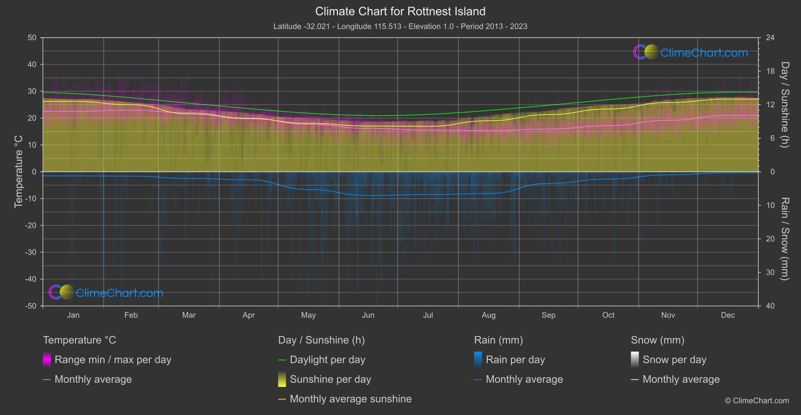
For Rottnest Island, Australia, the climate data cover 2013–2023. Monthly mean temperatures range from August at 15.3 °C to February at 22.9 °C, giving a useful picture of the cooler and warmer ends of the year without implying daytime highs. Rainfall and sunshine also vary by month, so visitors can use those patterns to guide planning while remembering that averages do not describe every day.
Climate overview
Temperature
The monthly mean temperature reaches its high in February, at 22.9 °C, while the low is in August, at 15.3 °C. These are averages for each month, not daytime maximum temperatures, so they describe the broad monthly pattern rather than the range visitors may experience within a day. Across the calendar-month means, the unweighted mean is 18.8 °C. It is a summary of monthly averages, not a day-weighted annual figure.
Rain
Mean daily rainfall is highest in June, at 3.53 mm/day, and lowest in December, at 0.16 mm/day. These figures are daily means for the respective months, not monthly totals; the lower average does not guarantee rain-free days or indicate how frequently rain occurs. The unweighted mean across monthly daily-rainfall averages is 1.64 mm/day. This provides a broad reference rather than a description of rainfall on any particular day.
Sunshine
Mean daily sunshine duration is highest in December, at 12.99 hours/day, and lowest in July, at 8.13 hours/day. These are average sunshine hours, not measures of day length, and neither value guarantees the conditions on a specific day. The unweighted mean of the monthly sunshine averages is 10.44 hours/day per day, a useful overview but not a day-by-day forecast.
Best Travel Time Guide for Rottnest Island, Australia: Ideal Seasons and Weather Insights
For visitors prioritising cooler monthly mean conditions, August is the relevant option, with a monthly mean of 15.3 °C; this is not a daytime high and cannot show the conditions on an individual visit. If lower average rainfall is the main criterion, December is the option indicated by the lowest mean daily rainfall, 0.16 mm/day, though that average does not promise dry days. Plan for rain with the higher monthly daily mean in mind: June records 3.53 mm/day. Because this is a daily average rather than a monthly total or a measure of rain frequency, it cannot specify when showers will occur; flexible outdoor plans and suitable rain protection remain sensible.
For outdoor sightseeing where average sunshine is a priority, December has the highest mean daily duration at 12.99 hours/day. The lowest sunshine average is in July, at 8.13 hours/day; these figures can help with broad planning, but sunshine duration is not day length and does not forecast the weather for a particular date.
Climate Data Overview for Rottnest Island, Australia
Explore the comprehensive climate data for Rottnest Island, Australia. This detailed table provides valuable insights into temperature variations, precipitation levels, and seasonal changes, helping you understand the unique weather patterns of this region.
| Month | Average: Temperature °C | Rain (mm) / day | Snow (mm) / day | Sunshine (h) / day |
|---|---|---|---|---|
| Jan | 22.5 | 0.62 | 0.00 | 12.59 |
| Feb | 22.9 | 0.65 | 0.00 | 11.99 |
| Mar | 22.0 | 1.00 | 0.00 | 10.36 |
| Apr | 20.0 | 1.19 | 0.00 | 9.50 |
| May | 17.6 | 2.64 | 0.00 | 8.65 |
| Jun | 16.1 | 3.53 | 0.00 | 8.18 |
| Jul | 15.5 | 3.40 | 0.00 | 8.13 |
| Aug | 15.3 | 3.24 | 0.00 | 9.12 |
| Sep | 15.9 | 1.74 | 0.00 | 10.23 |
| Oct | 17.2 | 1.09 | 0.00 | 11.22 |
| Nov | 19.2 | 0.46 | 0.00 | 12.37 |
| Dec | 21.0 | 0.16 | 0.00 | 12.99 |
| Average | 18.8 | 1.64 | 0.00 | 10.44 |