Climate Chart of Powder Mountain, USA
Monthly data: Temperature °C, Rain (mm), Sunshine (h) · 2013–2023
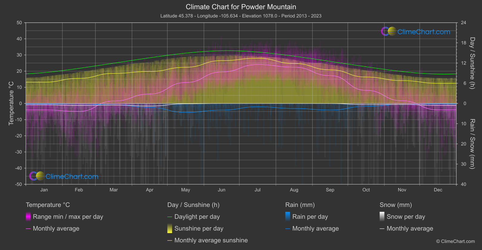
At Powder Mountain, USA, the climate data describe 2013–2023, with monthly mean temperatures spanning from February at -4.9 °C to July at 24.1 °C. The broad pattern includes a colder part of the year and a warmer midsummer, while sunshine and precipitation also vary across the calendar. These figures offer a useful orientation for planning, but monthly means do not describe conditions on every day or at every hour.
Climate overview
Temperature
Monthly mean temperatures are lowest in February at -4.9 °C, and reach their highest point in July at 24.1 °C. The mean across the calendar-month means is 8.4 °C; it is an unweighted summary, not a day-weighted annual average. These values describe monthly averages rather than daytime highs, overnight lows, or the temperature a visitor should expect on a particular date.
Snow
Mean daily snowfall is highest in April at 6.40 mm/day; the unweighted mean across the calendar-month means is 2.44 mm/day. These daily averages do not establish how many days have snowfall, the snow depth or cover, or whether conditions are suitable for skiing.
Rain
Mean daily rainfall is highest in May at 2.21 mm/day, while the lowest monthly mean is in December at 0.07 mm/day. The unweighted mean of the calendar-month means is 0.83 mm/day. These are daily average amounts, not monthly totals: they do not show how often rain falls or guarantee that any particular day will be wet or dry.
Sunshine
Average daily sunshine reaches its highest monthly mean in July at 13.44 hours/day, and its lowest in December at 5.99 hours/day. Across the calendar-month means, the unweighted mean is 9.30 hours/day. Sunshine duration can help with broad outdoor-planning expectations, but it measures neither daylight length nor the conditions on a specific day.
Best Travel Time Guide for Powder Mountain, USA: Ideal Seasons and Weather Insights
For visitors prioritising cooler monthly averages, February is the relevant reference point, with a mean temperature of -4.9 °C; pack with the possibility of colder conditions in mind, since this is not a forecast for individual days. If lower average rainfall is your priority, December is the lowest-rainfall option in these figures at 0.07 mm/day mean daily rainfall, while May has the highest monthly mean at 2.21 mm/day. Carrying rain protection is sensible when visiting, especially with that higher-rainfall average in mind, but neither figure tells you how frequently rain occurs or ensures dry or wet days. For outdoor plans that benefit from longer average sunshine duration, July has the highest mean at 13.44 hours/day; December has the lowest at 5.99 hours/day. These are daily sunshine averages, not measures of day length, and they cannot guarantee clear weather during a visit. The recorded snowfall mean is highest in April at 6.40 mm/day per day. Use this as a broad weather-planning indicator only: it does not specify snowy-day frequency, snow cover, depth, or skiing conditions.
Climate Data Overview for Powder Mountain, USA
Explore the comprehensive climate data for Powder Mountain, USA. This detailed table provides valuable insights into temperature variations, precipitation levels, and seasonal changes, helping you understand the unique weather patterns of this region.
| Month | Average: Temperature °C | Rain (mm) / day | Snow (mm) / day | Sunshine (h) / day |
|---|---|---|---|---|
| Jan | -4.0 | 0.08 | 3.40 | 6.32 |
| Feb | -4.9 | 0.14 | 4.80 | 7.46 |
| Mar | 1.5 | 0.29 | 3.85 | 8.93 |
| Apr | 5.8 | 0.97 | 6.40 | 9.51 |
| May | 12.9 | 2.21 | 0.82 | 10.75 |
| Jun | 19.5 | 1.64 | 0.00 | 12.72 |
| Jul | 24.1 | 0.82 | 0.00 | 13.44 |
| Aug | 22.5 | 1.23 | 0.00 | 11.87 |
| Sep | 17.2 | 1.62 | 0.12 | 9.99 |
| Oct | 8.1 | 0.71 | 2.95 | 7.84 |
| Nov | 1.7 | 0.22 | 2.31 | 6.78 |
| Dec | -3.9 | 0.07 | 4.63 | 5.99 |
| Average | 8.4 | 0.83 | 2.44 | 9.30 |