Climate Chart of Houston, USA
Monthly data: Temperature °C, Rain (mm), Sunshine (h) · 2013–2023
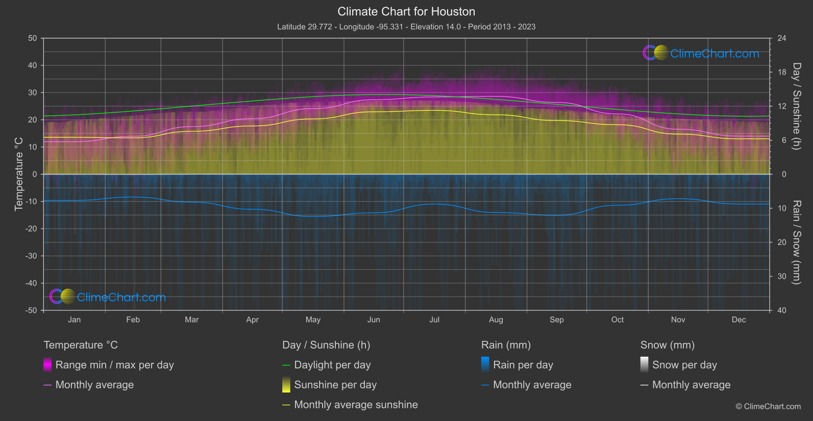
For Houston, USA, the climate data describe 2013–2023. The monthly mean temperature ranges from 11.9 °C in January to 28.6 °C in August, placing the year’s coolest and warmest monthly averages at distinctly different points. Rainfall and sunshine also vary by month, while the snowfall record is small on a daily-mean scale. These figures offer a broad planning guide, but monthly averages do not describe the conditions on any particular day.
Climate overview
Temperature
Monthly mean temperatures are lowest at 11.9 °C in January and highest at 28.6 °C in August. These are averages for whole months, not daytime highs or a forecast of how warm or cool an individual day will feel. The unweighted mean across the monthly means is 20.9 °C; it is a summary of those calendar-month averages rather than a day-weighted annual average.
Rain
Mean daily rainfall reaches its monthly high of 6.22 mm/day in May, while the monthly low is 3.35 mm/day in February. The unweighted mean across monthly daily-rainfall means is 4.74 mm/day. These are daily averages, not monthly rainfall totals: they cannot show how often rain occurs, how it is distributed, or whether a particular day will be wet.
Sunshine
Mean daily sunshine is highest at 11.26 hours/day in July and lowest at 6.25 hours/day in December. The unweighted mean across the monthly sunshine means is 8.59 hours/day. These figures can help frame expectations for average sunshine during outdoor plans, but they measure sunshine duration, not day length, and do not guarantee the conditions on a given day.
Snow
The highest monthly mean daily snowfall is 0.17 mm/day in February, and the unweighted mean across monthly daily-snowfall means is 0.02 mm/day. These small daily averages record snowfall amounts; they do not establish how many snowy days occur, the depth of snow, whether snow cover forms, or whether conditions are suitable for skiing.
Best Travel Time Guide for Houston, USA: Ideal Seasons and Weather Insights
If lower average rainfall is your priority, February is the conditional option in the record, with mean daily rainfall of 3.35 mm/day. This is not a promise of dry days or a measure of rain frequency, so retain flexible plans and prepare for changing weather. For rain preparation, note the monthly high: 6.22 mm/day of mean daily rainfall in May; the figure is not a monthly total. For visitors prioritising cooler monthly averages, January has the lowest monthly mean temperature, 11.9 °C; this does not predict daytime highs or the temperature on a specific visit. For daylight outdoor planning, mean daily sunshine is highest in July at 11.26 hours/day, and lowest in December at 6.25 hours/day. Sunshine duration is not day length, and these criteria point to separate considerations rather than a single universally best time to visit.
Climate Data Overview for Houston, USA
Explore the comprehensive climate data for Houston, USA. This detailed table provides valuable insights into temperature variations, precipitation levels, and seasonal changes, helping you understand the unique weather patterns of this region.
| Month | Average: Temperature °C | Rain (mm) / day | Snow (mm) / day | Sunshine (h) / day |
|---|---|---|---|---|
| Jan | 11.9 | 3.84 | 0.08 | 6.51 |
| Feb | 13.9 | 3.35 | 0.17 | 6.41 |
| Mar | 17.5 | 4.09 | 0.00 | 7.57 |
| Apr | 20.4 | 5.15 | 0.00 | 8.51 |
| May | 24.1 | 6.22 | 0.00 | 9.76 |
| Jun | 27.4 | 5.67 | 0.00 | 11.01 |
| Jul | 28.4 | 4.38 | 0.00 | 11.26 |
| Aug | 28.6 | 5.62 | 0.00 | 10.48 |
| Sep | 26.4 | 6.03 | 0.00 | 9.46 |
| Oct | 22.2 | 4.55 | 0.00 | 8.73 |
| Nov | 16.5 | 3.59 | 0.02 | 7.08 |
| Dec | 14.0 | 4.37 | 0.03 | 6.25 |
| Average | 20.9 | 4.74 | 0.02 | 8.59 |