Climate Chart of Haida Gwaii, Canada
Comprehensive Climate Chart of Haida Gwaii, Canada: Monthly Averages and Weather Trends
Discover the climate of Haida Gwaii, Canada
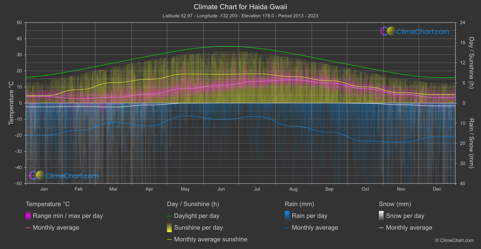
Haida Gwaii, formerly known as the Queen Charlotte Islands, is an archipelago located off the northwest coast of British Columbia, Canada. The climate in Haida Gwaii is classified as maritime temperate rainforest, characterized by mild, wet winters and cool summers. The area receives abundant rainfall throughout the year, contributing to its lush green landscapes and diverse ecosystems.
Best Travel Time Guide for Haida Gwaii, Canada: Ideal Seasons and Weather Insights
The best time to travel to Haida Gwaii is during the summer months, from June to August, when the weather is milder and outdoor activities can be enjoyed to the fullest. However, visitors should be prepared for rain at any time of the year due to the region's consistent rainfall. Spring and fall are also good times to visit for those looking to experience the changing seasons and fewer crowds.
Climate Data Overview for Haida Gwaii, Canada
Explore the comprehensive climate data for Haida Gwaii, Canada. This detailed table provides valuable insights into temperature variations, precipitation levels, and seasonal changes, helping you understand the unique weather patterns of this region.
| Month | ⌀ Temperature °C | ⌀ Rain (mm) | ⌀ Snow (mm) | ⌀ Sunshine (h) |
|---|---|---|---|---|
| Jan | 4.0 | 7.99 | 0.97 | 2.17 |
| Feb | 2.9 | 6.81 | 0.86 | 4.02 |
| Mar | 3.6 | 4.84 | 0.99 | 6.09 |
| Apr | 5.6 | 5.63 | 0.48 | 7.09 |
| May | 9.0 | 3.19 | 0.03 | 8.67 |
| Jun | 11.1 | 4.06 | 0.00 | 8.60 |
| Jul | 13.6 | 3.34 | 0.00 | 8.72 |
| Aug | 14.4 | 5.75 | 0.00 | 7.87 |
| Sep | 12.4 | 7.26 | 0.00 | 6.65 |
| Oct | 8.9 | 9.43 | 0.06 | 4.81 |
| Nov | 5.5 | 9.71 | 0.42 | 3.10 |
| Dec | 3.4 | 8.39 | 0.71 | 2.53 |
| ⌀ Month | 7.9 | 6.37 | 0.38 | 5.86 |