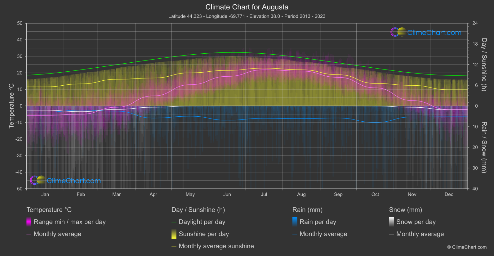
Climate Chart of Augusta, USA
Comprehensive Climate Chart of Augusta, USA: Monthly Averages and Weather Trends
Discover the Climate of Augusta, USA
Augusta, located in the state of Georgia, experiences a humid subtropical climate with hot summers and mild winters. The average annual temperature is around 65°F (18°C), with July being the warmest month and January the coldest. Rainfall is spread fairly evenly throughout the year, with occasional thunderstorms in the summer months.
Best Travel Time Guide for Augusta, USA: Ideal Seasons and Weather Insights
The best time to travel to Augusta is during the spring and fall months when the weather is pleasant and outdoor activities can be enjoyed. Avoid the peak of summer if you are not a fan of high temperatures, and pack some layers for the cooler winter months.
Climate Data Overview for Augusta, USA
Explore the comprehensive climate data for Augusta, USA. This detailed table provides valuable insights into temperature variations, precipitation levels, and seasonal changes, helping you understand the unique weather patterns of this region.
| Month | ⌀ Temperature °C | ⌀ Rain (mm) | ⌀ Snow (mm) | ⌀ Sunshine (h) |
|---|---|---|---|---|
| Jan | -5.7 | 1.50 | 1.03 | 5.53 |
| Feb | -5.0 | 1.01 | 1.39 | 6.39 |
| Mar | -0.8 | 1.26 | 0.82 | 7.73 |
| Apr | 6.1 | 2.94 | 0.31 | 8.10 |
| May | 12.8 | 2.48 | 0.02 | 9.61 |
| Jun | 17.8 | 3.44 | 0.00 | 10.31 |
| Jul | 21.8 | 2.97 | 0.00 | 10.97 |
| Aug | 21.1 | 3.04 | 0.00 | 10.49 |
| Sep | 17.3 | 2.92 | 0.00 | 9.06 |
| Oct | 10.9 | 3.99 | 0.02 | 6.53 |
| Nov | 3.3 | 2.66 | 0.32 | 5.96 |
| Dec | -2.2 | 2.62 | 0.94 | 4.70 |
| ⌀ Month | 8.1 | 2.57 | 0.40 | 7.95 |