Climate Change Chart of San Antonio, USA
Comprehensive Climate Change Chart of San Antonio, USA: Monthly Averages and Impact Trends
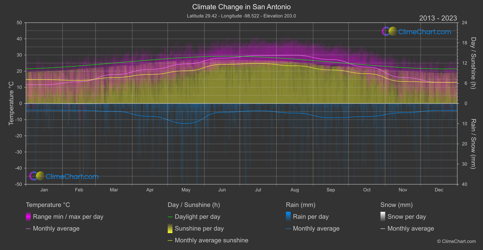
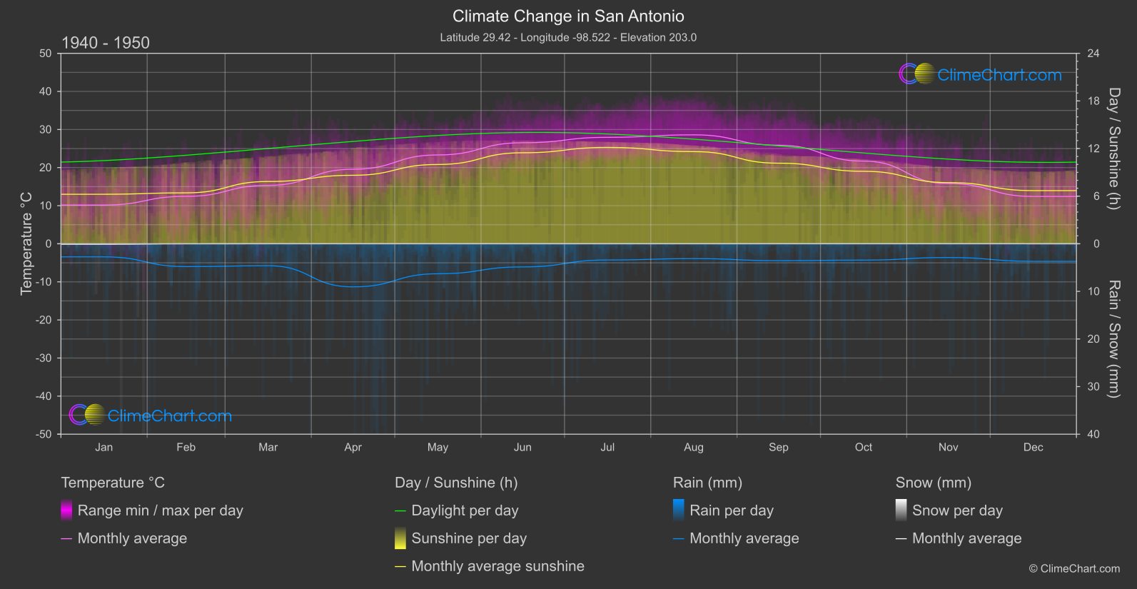
For San Antonio, USA, the comparison from 1940–1950 to 2013–2023 shows differences in monthly temperature, rainfall and sunshine averages.
Averaged across calendar months, monthly mean temperature was higher by +1.26 °C in the more recent reference period; this unweighted comparison of monthly means does not describe every month or daytime maximum temperatures. The largest monthly mean temperature increase was in March, with a difference of +2.55 °C compared with the earlier reference period.
Overview of climate changes
Temperature changes
Averaged across calendar months, monthly mean temperature was higher by +1.26 °C in the more recent reference period; this unweighted comparison of monthly means does not describe every month or daytime maximum temperatures. The largest monthly mean temperature increase was in March, with a difference of +2.55 °C compared with the earlier reference period.
Changes in rainfall
Mean daily rainfall, averaged across calendar months, was higher by +0.36 mm/day; this is a comparison of daily averages, not monthly rainfall totals, and does not mean every month was wetter. The largest monthly rainfall increase was in May, at +1.80 mm/day in mean daily rainfall, while the largest decrease was in April, at a difference of -1.34 mm/day.
Changes in sunshine duration
Mean daily sunshine duration averaged across calendar months was lower by -0.16 hours/day; the monthly pattern was not uniform, with the largest increase in January at +0.85 hours/day and the largest decrease in November at a difference of -1.18 hours/day.
Climate Change Data Overview for San Antonio, USA
Explore the comprehensive climate change data for San Antonio, USA. This detailed table provides valuable insights into temperature variations, precipitation levels, and seasonal changes influenced by climate change, helping you understand the unique weather patterns of this region.
Temperature °C
| Month | ⌀ 1940 - 1950 | ⌀ 2013 - 2023 | +/- |
|---|---|---|---|
| Jan | 10.17 | 11.62 | 1.46 |
| Feb | 12.45 | 13.40 | 0.95 |
| Mar | 15.33 | 17.88 | 2.55 |
| Apr | 19.57 | 21.03 | 1.46 |
| May | 23.32 | 24.45 | 1.12 |
| Jun | 26.53 | 28.02 | 1.50 |
| Jul | 27.94 | 29.62 | 1.68 |
| Aug | 28.60 | 29.83 | 1.23 |
| Sep | 25.88 | 27.18 | 1.31 |
| Oct | 21.70 | 22.53 | 0.83 |
| Nov | 15.80 | 16.11 | 0.31 |
| Dec | 12.42 | 13.14 | 0.72 |
| ⌀ Month | 19.98 | 21.23 | 1.26 |
Sunshine (h) / day
| Month | ⌀ 1940 - 1950 | ⌀ 2013 - 2023 | +/- |
|---|---|---|---|
| Jan | 6.24 | 7.09 | 0.85 |
| Feb | 6.42 | 6.83 | 0.42 |
| Mar | 7.85 | 7.69 | -0.16 |
| Apr | 8.63 | 8.62 | -0.02 |
| May | 9.99 | 9.69 | -0.30 |
| Jun | 11.47 | 11.59 | 0.12 |
| Jul | 12.15 | 11.88 | -0.26 |
| Aug | 11.61 | 11.19 | -0.42 |
| Sep | 10.15 | 9.96 | -0.20 |
| Oct | 9.13 | 8.85 | -0.28 |
| Nov | 7.71 | 6.53 | -1.18 |
| Dec | 6.70 | 6.27 | -0.43 |
| ⌀ Month | 9.00 | 8.85 | -0.16 |
Rain (mm) / day
| Month | ⌀ 1940 - 1950 | ⌀ 2013 - 2023 | +/- |
|---|---|---|---|
| Jan | 1.37 | 1.65 | 0.28 |
| Feb | 2.40 | 1.70 | -0.70 |
| Mar | 2.31 | 1.94 | -0.37 |
| Apr | 4.53 | 3.19 | -1.34 |
| May | 3.15 | 4.95 | 1.80 |
| Jun | 2.43 | 2.16 | -0.27 |
| Jul | 1.70 | 1.80 | 0.10 |
| Aug | 1.56 | 2.37 | 0.81 |
| Sep | 1.78 | 3.54 | 1.76 |
| Oct | 1.72 | 3.25 | 1.53 |
| Nov | 1.44 | 2.29 | 0.85 |
| Dec | 1.84 | 1.71 | -0.14 |
| ⌀ Month | 2.19 | 2.55 | 0.36 |
Snow (mm) / day
| Month | ⌀ 1940 - 1950 | ⌀ 2013 - 2023 | +/- |
|---|---|---|---|
| Jan | 0.50 | 0.06 | -0.44 |
| Feb | 0.05 | 0.38 | 0.33 |
| Mar | 0.00 | 0.00 | 0.00 |
| Apr | 0.00 | 0.00 | 0.00 |
| May | 0.00 | 0.00 | 0.00 |
| Jun | 0.00 | 0.00 | 0.00 |
| Jul | 0.00 | 0.00 | 0.00 |
| Aug | 0.00 | 0.00 | 0.00 |
| Sep | 0.00 | 0.00 | 0.00 |
| Oct | 0.00 | 0.00 | 0.00 |
| Nov | 0.00 | 0.00 | 0.00 |
| Dec | 0.02 | 0.02 | 0.00 |
| ⌀ Month | 0.05 | 0.04 | -0.01 |